
Seeing Mars in a different light
A team of Australian astronomers are developing a way of forecasting the weather on Mars – without putting their toes in space and have created beautiful images of our neighbouring planet.
Their discoveries will help us determine if Mars was a kinder place for life in the past.
And by forecasting the Martian weather they hope to be able to reduce the risks to spacecraft, such as the recent failed Beagle mission and possible future manned missions to Mars.
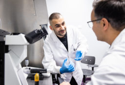
Sarah Chamberlain of the Australian Centre for Astrobiology and Dr Jeremy Bailey of the Anglo-Australian Observatory and the associate director of the ACA, observed Mars during its close approach to Earth in August 2003. They used the United Kingdom Infrared Telescope (UKIRT) on the summit of Mauna Kea, Hawaii.
By using near infra-red light they hoped to be able to map the distribution of elements in the atmosphere and on the surface of Mars. “Along the way we obtained the clearest images of Mars ever taken from Earth.”
The technique we used will help resolve the controversy as to whether water ever flowed across the surface of Mars. “We will be able to detect where rocks and minerals have been chemically altered by water flow.”
The most exciting application is a new technique to allow us to predict the weather on Mars.
The atmosphere on Mars is primarily carbon dioxide. By mapping the variations in carbon dioxide in the atmosphere and comparing this with topographical maps of Mars we can detect and monitor the movement of pressure systems (what we know as weather) in the Martian atmosphere.
Predicting the weather on Mars will reduce to risk to landing spacecraft “If we knew the weather systems on Mars, losses such as the recent Beagle 2 lander might be prevented”
“Our work shows that ground-based observations can still produce relevant and cutting-edge science without the cost and risk of launching a spacecraft. “Ground-based observations need not be relegated to the back bench when it comes to planetary exploration of our near-by neighbours,” says Sarah.
 |
 |
 |
|
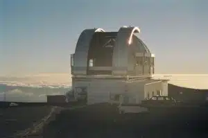
Image of the United Kingdom Infrared Telescope (UKIRT) on Mauna Kea Summit, Hawaii. The 3.8m telescope used to obtain images and spectra of Mars. |
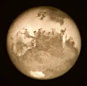
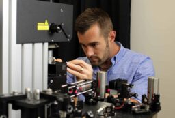
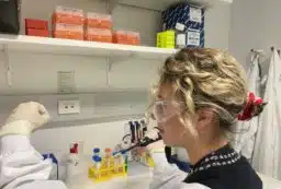
Possibly the sharpest image of Mars ever taken from a ground-based telescope. | Sarah Chamberlain at the controls of the UKIRT – (United Kingdom Infrared Telescope) observing Mars. |
 |
||
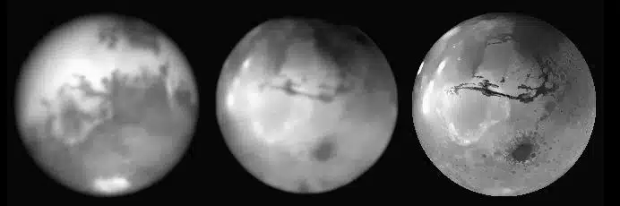
| Left-Right: An image of the near-infrared surface brightness of Mars showing features similar to those seen at visible light. Our topographic image of Mars obtained by looking at how carbon-dioxide varies across the Martian disk. Surface features can be seen that were only first discovered by spacecraft. NASA topographic image of Mars obtained by the orbiting instrument MOLA (Mars Orbiting Laser Altimeter) on the Mars Global Surveyor. By comparing this image with the topographic image we obtained, we are able to monitor the weather on Mars. |
||
 Fresh Science is on hold for 2022. We will be back in 2023.